華信光電將參加日本國際雷射加工技術展 Photonix 2016, 歡迎您的來訪!!
聚焦地科
聚焦地科2022-06-27
Drilling into a fault to capture 3D earthquake behavior
Drilling into a fault to capture 3D earthquake behavior
POSTED ON MAY 17, 2022 BY TEMBLOR
To know what happens to a fault during an earthquake, we need to have our eyes on it. A new drilling project gets instruments as close as possible to the source of a future earthquake in Taiwan.
By Kuo-Fong Ma, Ph.D., Institute of Earth Sciences, Academia Sinica, National Central University, and Kate Zalzal, science writer
Citation: Ma, K., Zalzal, K. 2022, Drilling into a fault to capture 3D earthquake behavior, Temblor, http://doi.org/10.32858/temblor.257
Along the Ryuku trench, deep off the eastern coast of Taiwan, the Philippine Sea plate subducts north underneath the Eurasian plate. Stress from this tectonic dance gathers along the Milun Fault, located inland near the Taiwanese city of Hualien. It is along this fault — one of the most active in Taiwan — that scientists are working to establish an ambitious and comprehensive long-term fault monitoring observatory.
The first of its kind, the project will deploy a three-dimensional array of optical fiber sensors across the Milun Fault below the surface, with boreholes drilled on its eastern and western flanks. Scientists hope to capture high-resolution observations of future quakes directly at their source. We presented our progress on the project at the Seismological Society of America annual meeting last month.
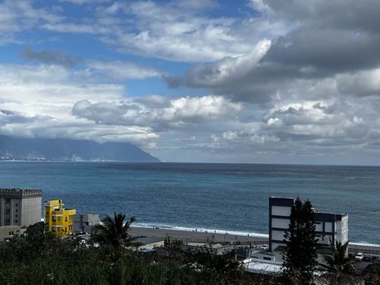
The Milun Fault observatory project is located near Hualien, a coastal city in eastern Taiwan. Credit: Kuo-Fong Ma
Drilling into active faults in the wake of an earthquake has helped scientists explore some of seismology’s trickiest questions, particularly those related to how an earthquake starts and how much energy is involved. Post-quake data, which is what scientists currently work with, provide an incomplete picture, especially regarding how heat produced by friction transfers throughout the subsurface.
The new project, called the Milun Fault Drilling and All-inclusive Sensing (MiDAS) project, aims to better capture a real-time three-dimensional picture of an earthquake through the installation of vertical optical fibers equipped with distributed acoustic sensing (DAS) and distributed temperature sensing (DTS) capabilities into boreholes and along the surface of the fault. The site will also include a vertical seismic array and fluid and gas monitoring.
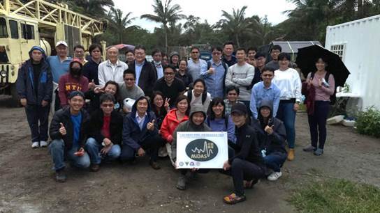
MiDAS project members at one of the drilling sites. Credit: Kuo-Fong Ma
Testing hypotheses of fault behavior
Some earthquakes are thought to be related to subsurface fluid behavior. But models are still hypothetical as there are limited observations along the fault surface below ground. The MiDAS team is hopeful that our high-resolution monitoring combined with the high seismicity of the region will provide a comprehensive picture of what happens before, during and after an earthquake.
Through the temperature sensor network, we also hope to be the first to capture the frictional heat generated in future earthquakes. This could help us understand where the heat goes during faulting, how fast it dissipates and how heat transmission relates to fluid migration — factors that heavily influence earthquake energy budgets.
The Milun fault is ideal for this work. We think it is connected below the surface to the nearby Ryuku subduction zone — a fault system that has the potential to generate megathrust earthquakes. Understanding subduction zone systems is a critical task in seismology, but, as it is often offshore, measurements are difficult and costly to obtain. The MiDAS site, located inland but close to the subduction zone, allows us to generate observations more easily. The first phase of coring, which reached a depth of 700 meters (nearly half a mile) and optical fiber installation was successfully completed in December 2021 on the eastern side of the Milun Fault. A 500-meter (1,600-foot) hole is set to be drilled on the western flank in May 2022.
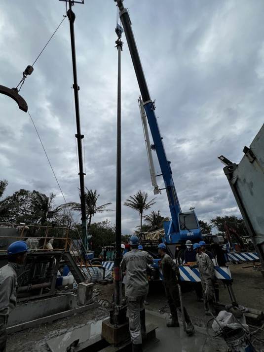
MiDAS project drilling on the Milun Fault’s eastern flank. Credit: Kuo-Fong Ma
We hope that the MiDAS project may help answer these big questions in earthquake research which would ultimately improve earthquake hazard forecasting. We expect to have a lot of data to dig through, but our challenge remains connecting the behavior of one fault to the interconnected workings of complex earthquake systems.
原文連結:Drilling into a fault to capture 3D earthquake behavior – Temblor
原文轉載自【國立中央大學 地震災害鏈風險評估及管理研究中心】
https://e-dream.tw/e-dream.tw/activities/馬國鳳主任-鑽井研究探索3d地震現象/
POSTED ON MAY 17, 2022 BY TEMBLOR
To know what happens to a fault during an earthquake, we need to have our eyes on it. A new drilling project gets instruments as close as possible to the source of a future earthquake in Taiwan.
By Kuo-Fong Ma, Ph.D., Institute of Earth Sciences, Academia Sinica, National Central University, and Kate Zalzal, science writer
Citation: Ma, K., Zalzal, K. 2022, Drilling into a fault to capture 3D earthquake behavior, Temblor, http://doi.org/10.32858/temblor.257
Along the Ryuku trench, deep off the eastern coast of Taiwan, the Philippine Sea plate subducts north underneath the Eurasian plate. Stress from this tectonic dance gathers along the Milun Fault, located inland near the Taiwanese city of Hualien. It is along this fault — one of the most active in Taiwan — that scientists are working to establish an ambitious and comprehensive long-term fault monitoring observatory.
The first of its kind, the project will deploy a three-dimensional array of optical fiber sensors across the Milun Fault below the surface, with boreholes drilled on its eastern and western flanks. Scientists hope to capture high-resolution observations of future quakes directly at their source. We presented our progress on the project at the Seismological Society of America annual meeting last month.
The Milun Fault observatory project is located near Hualien, a coastal city in eastern Taiwan. Credit: Kuo-Fong Ma
Drilling into active faults in the wake of an earthquake has helped scientists explore some of seismology’s trickiest questions, particularly those related to how an earthquake starts and how much energy is involved. Post-quake data, which is what scientists currently work with, provide an incomplete picture, especially regarding how heat produced by friction transfers throughout the subsurface.
The new project, called the Milun Fault Drilling and All-inclusive Sensing (MiDAS) project, aims to better capture a real-time three-dimensional picture of an earthquake through the installation of vertical optical fibers equipped with distributed acoustic sensing (DAS) and distributed temperature sensing (DTS) capabilities into boreholes and along the surface of the fault. The site will also include a vertical seismic array and fluid and gas monitoring.
MiDAS project members at one of the drilling sites. Credit: Kuo-Fong Ma
Testing hypotheses of fault behavior
Some earthquakes are thought to be related to subsurface fluid behavior. But models are still hypothetical as there are limited observations along the fault surface below ground. The MiDAS team is hopeful that our high-resolution monitoring combined with the high seismicity of the region will provide a comprehensive picture of what happens before, during and after an earthquake.
Through the temperature sensor network, we also hope to be the first to capture the frictional heat generated in future earthquakes. This could help us understand where the heat goes during faulting, how fast it dissipates and how heat transmission relates to fluid migration — factors that heavily influence earthquake energy budgets.
The Milun fault is ideal for this work. We think it is connected below the surface to the nearby Ryuku subduction zone — a fault system that has the potential to generate megathrust earthquakes. Understanding subduction zone systems is a critical task in seismology, but, as it is often offshore, measurements are difficult and costly to obtain. The MiDAS site, located inland but close to the subduction zone, allows us to generate observations more easily. The first phase of coring, which reached a depth of 700 meters (nearly half a mile) and optical fiber installation was successfully completed in December 2021 on the eastern side of the Milun Fault. A 500-meter (1,600-foot) hole is set to be drilled on the western flank in May 2022.
MiDAS project drilling on the Milun Fault’s eastern flank. Credit: Kuo-Fong Ma
We hope that the MiDAS project may help answer these big questions in earthquake research which would ultimately improve earthquake hazard forecasting. We expect to have a lot of data to dig through, but our challenge remains connecting the behavior of one fault to the interconnected workings of complex earthquake systems.
原文連結:Drilling into a fault to capture 3D earthquake behavior – Temblor
原文轉載自【國立中央大學 地震災害鏈風險評估及管理研究中心】
https://e-dream.tw/e-dream.tw/activities/馬國鳳主任-鑽井研究探索3d地震現象/